Space | Earth Observation

Discovering natural phenomena

Whether the goal is to measure earth movements, update maps, chart resources, observe crisis zones, or monitor the interaction between oceans, polar ice and the atmosphere ...

SAR Lupe 5-Satellites-Constellation
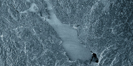
Satellite picture of the Lake Constance region

Digital satellite technology opens up new dimensions in earth observation when it comes to geophysical investigations, topographic and geological measurements as well as civil and military applications for the large-scale mapping of the earth's surface. In many cases, it is necessary to generate these images in adverse weather conditions both by night and day.

... Synthetic Aperture Radar (SAR) scans sections of the earth surface by using electro-magnetic waves, thus generating two-dimensional high-resolution images.

RST Designs SAR systems for you – from development to final product. Get more information at Technology.


Selected services of the RST portfolio

Reference project: GeoSAR (Geosynchronous SAR Processing Algorithm and Simulation)

RST analysed the possibilities for application of SAR on geosynchronous platforms.

Customer: CAST Xi’an (Chinese Academy of Science and Technology Xi‘an)

read more 

Product: New SLIP-SAR Processing Algorithm

RST Internally funded development of a new and highly effective SLIP-SAR Processor working in frequency domain.

read more 

Reference project: SMERALDA (Small and Medium Enterprises Research Analysis of Large Deployable Antennas)

Study for a scientific small satellite mission of DLR (German Aerospace Center).

Customer: RWTH Aachen, Institut für Hochfrequenztechnik

read more 

Reference project: SAR-LUPE

RST was responsible for the design and the image quality of the SAR System and has contributed significantly to the successful development of the SAR system since Phase A.

Customer: OHB Technology AG/BWB (Federal Office of Defense Technology and Procurement)

read more